
Satellite Heat Hazard Map Supports Resilience Planning Across UK
BRISTOL, UK / AGILITYPR.NEWS / June 23, 2020 / 4 Earth Intelligence Heat Hazard Data Supports Resilience Planning across UK
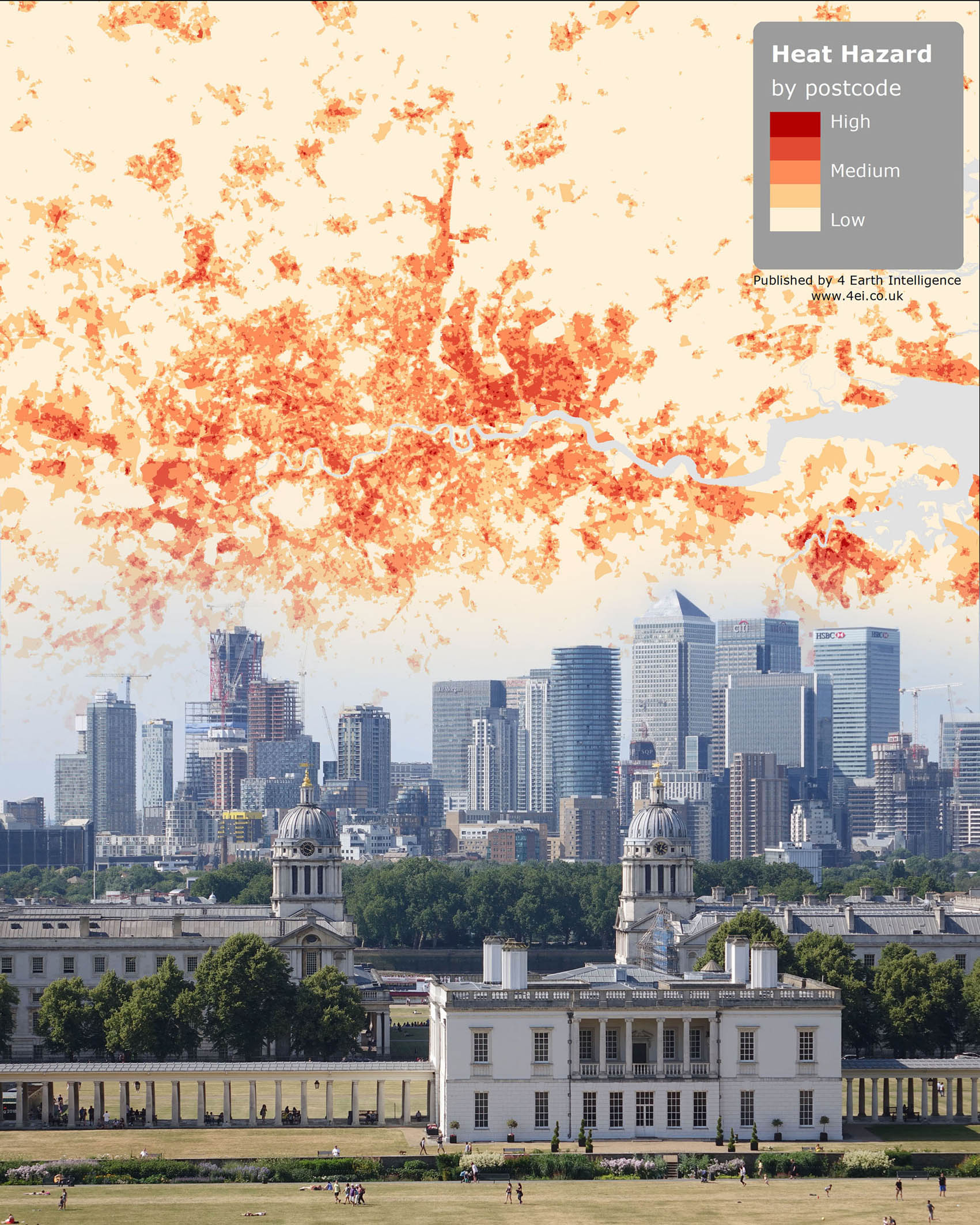
The UK’s first street level map of areas potentially at risk from extreme weather conditions has been warmly received since its launch last month. Created by earth observation company 4 Earth Intelligence (4EI), with support from the Ordnance Survey through its Covid-19 Response licencing, the free at point of use Heat Hazard Postcode data is already being used to plan the provision of urban green spaces, assess vulnerable populations and inform climate change strategy. Early adopters of the data include the Greater London Authority (GLA), numerous local authorities and several central government departments.
“We recognize the danger extreme temperatures pose and the beneficial role Space Data can play. This is particularly pertinent as we continue to face COVID-19 - undoubtedly the most significant public health challenge in generations,” commented Kristina Guida, Manager at the London Climate Change Partnership, part of the GLA. “The 4EI heat hazard postcode data will help us ensure that we can understand where the hazard lies and will support the mitigation planning for reducing the impact on our most vulnerable populations”
Increased day time temperatures, reduced night time cooling, and higher air pollution levels associated with urban areas can significantly impact human health. Contributing to general discomfort, respiratory difficulties, heat cramps and exhaustion the combination of temperature and pollution can also cause non-fatal heat stroke as well as heat related mortality. It is estimated that the heatwaves of 2019 led to almost 900 additional deaths in England and, with potentially vulnerable households still maintaining self-isolation, it is possible the figures for this year could be higher.
Derived from satellite imagery and created using automated algorithms, the 4EI data identifies hot spots, usually within urban areas, where temperatures can be up to 3-4 degrees higher forming what is known as an Urban Heat Island (UHI). An UHI is a metropolitan area that is warmer than its vicinity. Heat created by energy from people, cars, transport and building’s heating, cooling and ventilation systems, interacts with construction materials to elevate temperatures.
The 4EI Heat Hazard data is being supplied free at the point of use to national organisations and multi-agency partnerships, such as Local Resilience Forums, that are currently involved in the coronavirus response until September 2020. Supplied as a CSV file for use in spreadsheets, the Heat Hazard data includes five categories, demonstrating the tendency of different locations to reach higher temperatures.
For further information and access to this resource frontline organisations are encouraged to contact heat@4ei.co.uk to discuss eligibility, coverage and data access. A technical white paper associated with this product is available to download from the 4EI website.
About Us
4 Earth Intelligence (4EI) is a specialist in earth observation intelligence and data services. Built on decades of earth observation excellence, geospatial expertise and data analytics experience, 4EI creates data products, services and insights that enable organisations to manage risk and make informed decisions to improve outcomes.
With a focus on customer need 4EI designs solutions to solve core problems while ensuring data quality is proven, consistent and repeatable. 4EI has worked with government and commercial organisations, and leading academic institutions, to complete a range of projects including a new Global Air quality index, wide-scale habitat mapping and the use of machine learning for urban heat mapping.
4EI will focus on new sectors and technical innovations using machine learning and Artificial Intelligence to provide smart data for global environmental challenges such as climate change, pollution and population pressure. For further information www.4earthintelligence.com
WHAT IS EARTH OBSERVATION?
Earth observation is the collection of information about the physical, chemical and biological systems of the planet via remote sensing techniques; in other words measurement or information gathering from a distance. Earth observation includes monitoring and assessing the status of, and changes in the natural and man-made environments. Techniques and technologies used for earth observation can range from floating buoys used to monitor ocean currents, temperature and salinity right up to sophisticated satellite sensors.
It is currently estimated there are in the region of 2,000 artificial satellites orbiting the earth designated into separate categories or roles; including communications, navigation and Global Positioning Satellites (GPS). This classification also includes the overarching definition of remote sensing satellite which can itself include a wide variety of sensors, and therefore data captured, including imagery, radar and non-imaging sensors such as infra-red and hyperspectral.
Recent estimates suggest that there are around 700 earth observation satellites, a staggering growth of 250 percent in just four years, which allows for the globe’s entire landmass to be imaged, in its entirety, every day!
Contacts