Tree Map Reveals Subsidence Risk for Home Buyers
LEICESTERSHIRE, UK / AGILITYPR.NEWS / November 12, 2019 / Terrafirma, an expert provider of Hazard Models and Ground Risk Reports, has adopted Bluesky’s unique database of more than 300 million trees, within its advanced conveyancing search service. As part of a major upgrade, Terrafirma Ground Reports are now the first conveyancing search product to provide detailed, property-specific information on the risks from clay related subsidence and trees - a major cause of building damage in the UK.
“The addition of the Bluesky National Tree Map data to the Ground Report, tackles the problem of tree-related clay subsidence and provides homeowners with the advice and information they need prior to purchase,” commented Tom Backhouse, CEO and Founder of Terrafirma. “There is nothing else like it available within environmental reports and the advanced analysis we have been doing with the National Tree Map is another example of our commitment to enable professionals and the public to better understand what lies beneath.”
The Bluesky National Tree Map is the most detailed dataset of its kind ever produced. With coverage across the whole of England and Wales, the Bluesky National Tree Map provides a unique, comprehensive database of location, height and canopy/crown extents for trees 3m and above in height. A standalone geospatial database, the National Tree Map is created to the Ordnance Survey projection and is therefore compatible with all OS map layers.
The Terrafirma Ground Report is a property report designed to enable professionals, such as solicitors, mortgage lenders, property developers, and consumers better identify, manage and resolve risk from all man-made and natural ground hazards. Based on property level Ordnance Survey mapping Terrafirma’s Ground Reports include information relating to the UK’s extensive and varied mining heritage, subsidence, sinkholes, radon, mineral planning activity and many more perils.
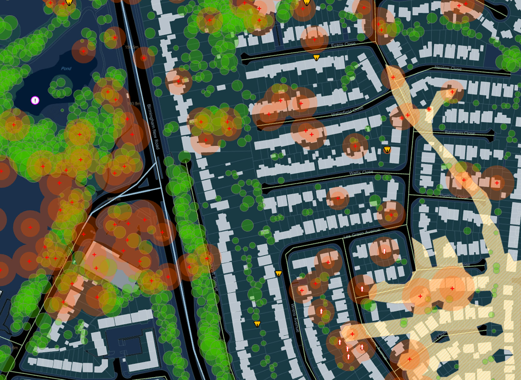
Terrafirma worked closely with Bluesky to give an accurate prediction of properties which are likely to suffer shrink-swell movements or be affected by nearby tree roots. The new Ground Report includes a simple-to-understand guide to the potential for ground movement as well as the zone of influence of large trees and gives clear guidance on the scope of building surveys and subsidence insurance for affected properties.
In an industry first, the latest Ground Reports include expert-evidence based modelling; assessing the risk of a potential hazard and also analysing a ‘proof of movement’ database that includes over 120,000 investigated subsidence claims and almost 10,000 sinkholes.
About Us
Bluesky is one of the leading and most successful aerial survey and geographic data companies in the UK producing and maintaining seamless digital aerial photography and height data on a national scale in both Great Britain and the Republic of Ireland.
Bluesky operates the worlds most advanced airborne sensor, which comprises vertical and oblique cameras as well as a LiDAR, to create accurate and detailed virtual cities. Bluesky also operates the only LiDAR system in the world that incorporates a thermal sensor and survey grade camera. These combined with other systems puts Bluesky in the enviable position of being able to provide customers with unique and cost-effective geospatial solutions.
As well as being an established and respected aerial survey company Bluesky is also highly innovative and continually strives to develop new products and services by embracing new technology and methods. This has resulted in the development of some unique products such as the National Tree Map (NTM).
These datasets underpin long term contracts with local and central governments and many major blue-chip companies from a range of market sectors including financial services, utilities, telecoms, web portals, construction and environment.
Bluesky has offices in the UK, US, Republic of Ireland and a dedicated production centre in India.
https://www.bluesky-world.com/
Terrafirma is a multi-disciplinary team of experts helping professionals unravel the complexities of the ground and providing intelligent solutions in the form of GeoData or Reports.
A highly specialised team extract knowledge from information captured on the ground, collaborating with hand-picked data partners, and more recently using data from space.
Terrafirma uses emerging technology to innovatively synthesise this data with a deep understanding of geo-science, gaining insight into hazards that can disrupt property, land and infrastructure. https://www.terrafirmaidc.co.uk/
Contacts